Brian Sperlongano
f744f9c009
Upgrade to omt-tools v6, Imposm 0.11.1 and migrate SQL ( #1246 )
...
This PR migrates the SQL in the transportation and transportation_name layer to use the new imposm3 mappings which now map a separate primary key ID.
2021-10-14 11:38:28 -04:00
Brian Sperlongano
d427d58e36
Water layer river mapping bug fixes ( #1182 )
...
This PR is a bugfix for the `water` layer.
* `waterway=stream`, `waterway=river`, `waterway=canal`, `waterway=ditch`, and `waterway=drain` are all linear features, not area features. Thus, these objects are being unnecessarily mapped into the `osm_water_polygon` polygon table, and this PR removes these unneeded mappings.
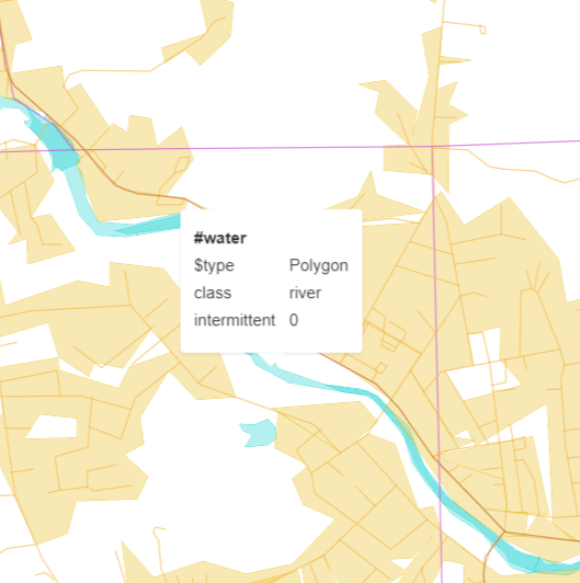
* The combination `natural=water` + `water=river` is the most popular tagging for river areas. However, the current mapping causes rivers tagged in this way to be rendered in the vector tiles as a `lake`. This PR adds a check for the `water=river` tag and tags both variants of river areas as `class=river`.
`natural=water` + `water=river` river mapping:
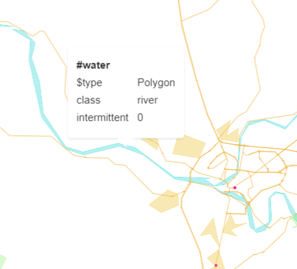
`waterway=riverbank` river mapping:
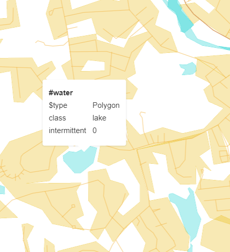
Lake mapping for a `natural=water` (with no other tagging):
2021-09-01 08:24:01 +02:00
zstadler
e37076c133
Add spring water bodies ( #1167 )
...
The [OSM wiki](https://wiki.openstreetmap.org/wiki/Tag:natural%3Dspring ) says `natural=spring` may be used on areas.
2021-08-18 17:46:15 +02:00
Frédéric Rodrigo
a3ce04fe23
Add landuse=salt_pond as water ( #1000 )
...
Add salt pond as water.

Most of salt pond are already tagged with natural=water even if it's not required. So the load added by this tag is very light.
2020-09-29 07:53:35 +03:00
Frédéric Rodrigo
e808590a4a
Add landuse=basin as water ( #876 )
...
Add support of tag landuse=basin as water polygon.
2020-05-22 14:45:18 +02:00
Jan-Philipp Benecke
f5d34b5949
Mapping leisure=swimming_pool as water ( #878 )
...
Adds tag leisure=swimming_pool as water polygon
2020-05-22 10:31:47 +02:00
Yuri Astrakhan
eca13f9bed
Refreshed all diagrams, fixed automation & 2 broken graphs ( #692 )
...
Seems like etl and mapping diagrams have been neglected
for a long time. Now it regenerates the files and places
them in the source dir.

This PR also fixes two broken files:
* layers/aerodrome_label/mapping_diagram.png
* layers/housenumber/mapping_diagram.png

They were generated using the newest tools version with the fix
https://github.com/openmaptiles/openmaptiles-tools/pull/65
2019-10-26 21:28:43 -04:00
jirik
1b01399e1d
Update diagrams
2017-06-12 18:13:09 +02:00